![](/images/other/stat-length.png)
![Tocht Stappen La Ferté-Vidame - TCP Etape 4/8 La Ferté Vidame - Tourouvre - Photo](https://media.geolcdn.com/t/1900/400/ext.pjpeg?maxdim=2&url=https%3A%2F%2Fstatic1.geolcdn.com%2Fsiteimages%2Fupload%2Ffiles%2F1553511878bg_sport_marche.png)
TCP Etape 4/8 La Ferté Vidame - Tourouvre
ODDAD78
Gebruiker
![Lengte](/images/other/stat-length.png)
![Max. hoogte](https://static1.geolcdn.com/siteimages/upload/files/1508320355ic_sort_altitude_max_24dp.png)
![Positief hoogteverschil](https://static1.geolcdn.com/siteimages/upload/files/1508320355ic_sort_den_pos_24dp.png)
![Km-Effort](/images/other/stat-length.png)
![Min. hoogte](https://static1.geolcdn.com/siteimages/upload/files/1508320355ic_sort_altitude_min_24dp.png)
![Negatief hoogteverschil](https://static1.geolcdn.com/siteimages/upload/files/1508320355ic_sort_den_neg_24dp.png)
![Boucle](https://static1.geolcdn.com/siteimages/upload/files/16400158638029165_repeat_loop_refresh_sync_direction_icon.png)
![Stappen](https://static1.geolcdn.com/sitytour/trail-icons/101.png)
7h09
Moeilijkheid : Medium
![Scan deze QR-code om de tocht te openen in de SityTrail-applicatie](https://capi.geolives.com/qq0zvz2zws4bq2lad0pu/sitytour/trails/536417/qr.png?size=200)
Gratisgps-wandelapplicatie
Over ons
Tocht Stappen van 32 km beschikbaar op Centre-Val de Loire, Eure-et-Loir, La Ferté-Vidame. Deze tocht wordt voorgesteld door ODDAD78.
Beschrijving
Le TOUR des COLLINES du PERCHE est une randonnée multi-étapes de 8 jours que vous propose l’association Itinéraires Ruraux, dont la vocation principale est la sauvegarde des chemins de randonnée percherons.
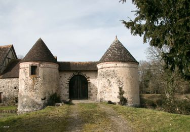
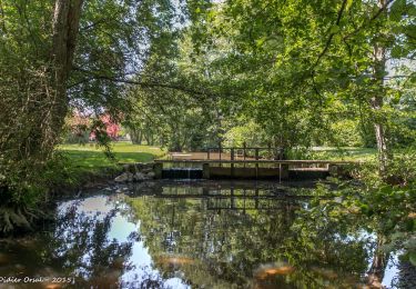
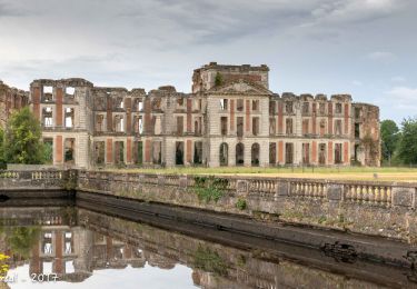
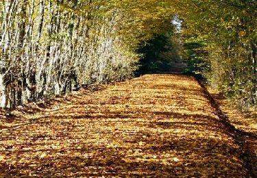
Ce circuit de randonnée conçu et réalisé par des randonneurs itinérants. Le Tour des Collines du Perche vous fera en effet découvrir le Perche ornais et eurélien, son bocage, ses collines, ses vallées, ses forêts (filles de la célèbre forêt des Carnutes) à l’ombre de ses nombreux manoirs, églises, chapelles et de mile autres endroits tous plus envoûtants et magiques les uns que les autres.
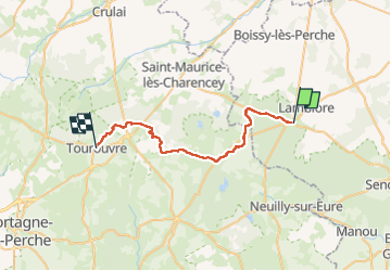
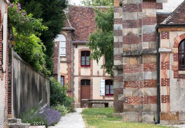
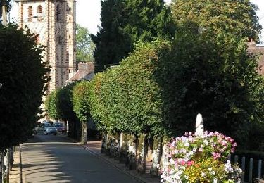
Vous serez certainement étonnés de la diversité des paysages que vous traverserez au cours d'un périple qui, à partir de Nogent-le-Rotrou (gare SNCF, et accès de Paris par l’Autoroute A11 ou la RN 23 ), vous fera passer par des villes ou villages étapes typiquement percherons et chargés d’Histoire, Rémalard (étape 1), Moutiers-au-Perche (étape 2), La Ferté-Vidame (étape 3), Tourouvre (étape 4), Mortagne-au-Perche (étape 5), La Perrière (étape 6), Saint Germain de la Coudre (étape 7 ou sa variante 7 bis vers le promontoire de Bellême) avant de revenir à Nogent-le-Rotrou (étape 8).
Au long de cette étape 5, la forêt du Perche et de la Trappe, la randonnée fait un large détour par Autheuil et la forêt de Réno-Valdieu avant de se diriger vers Mortagne-au-Perche, l’une des trois capitales historiques de l’ancienne province du Perche.
Plaatsbepaling
Opmerkingen
Wandeltochten in de omgeving
![Tocht Stappen La Ferté-Vidame - La Ferté-Vidame - Longny-au-Perche (Longny-les-Villages) 23 km - Photo](https://media.geolcdn.com/t/375/260/5ed99afd-b5c6-42e1-9343-ce75df697bb2.jpg&format=jpg&maxdim=2)
![Stappen Stappen](https://static1.geolcdn.com/sitytour/trail-icons/101.png)
Stappen
![](/images/other/stat-length.png)
![](https://static1.geolcdn.com/siteimages/upload/files/16400158638029165_repeat_loop_refresh_sync_direction_icon.png)
![Tocht Stappen La Ferté-Vidame - Traversées Percheronnes La-Ferté-Vidame - Tourouvre Etape 4 du TCP 28,7 Km - Photo](https://media.geolcdn.com/t/375/260/d98149be-773b-466c-b336-70c46d69328d.jpg&format=jpg&maxdim=2)
![Stappen Stappen](https://static1.geolcdn.com/sitytour/trail-icons/101.png)
Stappen
![](/images/other/stat-length.png)
![](https://static1.geolcdn.com/siteimages/upload/files/16400158638029165_repeat_loop_refresh_sync_direction_icon.png)
![Tocht Stappen La Ferté-Vidame - La Ferté-Vidame - Moutiers-au-Perche (TCP) 28 km - Photo](https://media.geolcdn.com/t/375/260/17f1064c-f2d0-4388-8493-f7f18ee11920.jpg&format=jpg&maxdim=2)
![Stappen Stappen](https://static1.geolcdn.com/sitytour/trail-icons/101.png)
Stappen
![](/images/other/stat-length.png)
![](https://static1.geolcdn.com/siteimages/upload/files/16400158638029165_repeat_loop_refresh_sync_direction_icon.png)
![Tocht Stappen La Ferté-Vidame - La Ferté-Vidame - Saint-Maurice-lès-Charencey 15 km - Photo](https://media.geolcdn.com/t/375/260/6ed3707c-f3e2-46d2-9930-16239d79219c.jpg&format=jpg&maxdim=2)
![Stappen Stappen](https://static1.geolcdn.com/sitytour/trail-icons/101.png)
Stappen
![](/images/other/stat-length.png)
![](https://static1.geolcdn.com/siteimages/upload/files/16400158638029165_repeat_loop_refresh_sync_direction_icon.png)
![Tocht Stappen La Ferté-Vidame - La Ferté Vidame 6 - Photo](https://media.geolcdn.com/t/375/260/ext.jpg?maxdim=2&url=https%3A%2F%2Fstatic1.geolcdn.com%2Fsiteimages%2Fupload%2Ffiles%2F1553511878bg_sport_marche.png)
![Stappen Stappen](https://static1.geolcdn.com/sitytour/trail-icons/101.png)
Stappen
![](/images/other/stat-length.png)
![](https://static1.geolcdn.com/siteimages/upload/files/16400158638029165_repeat_loop_refresh_sync_direction_icon.png)
![Tocht Stappen La Ferté-Vidame - La Ferté-Vidame - Senonches 17 km - Photo](https://media.geolcdn.com/t/375/260/dc48b6f8-8e0a-4753-a60e-6bc96e6543fb.jpg&format=jpg&maxdim=2)
![Stappen Stappen](https://static1.geolcdn.com/sitytour/trail-icons/101.png)
Stappen
![](/images/other/stat-length.png)
![](https://static1.geolcdn.com/siteimages/upload/files/16400158638029165_repeat_loop_refresh_sync_direction_icon.png)
![Tocht Mountainbike La Ferté-Vidame - Autour de la forêt (Etape 1) - La Ferté-Vidame - Photo](https://media.geolcdn.com/t/375/260/ext.jpg?maxdim=2&url=https%3A%2F%2Fservices.sitytrail.com%2FGeolivesWS%2FDownloadMedia.ashx%3FTrailID%3D172714%26Media%3D14101_2.jpg)
![Mountainbike Mountainbike](https://static1.geolcdn.com/sitytour/trail-icons/202.png)
Mountainbike
![](/images/other/stat-length.png)
![](https://static1.geolcdn.com/siteimages/upload/files/16400158638029165_repeat_loop_refresh_sync_direction_icon.png)
![Tocht Stappen La Ferté-Vidame - Autour de la forêt (Etape 1) - La Ferté-Vidame - Photo](https://media.geolcdn.com/t/375/260/ext.jpg?maxdim=2&url=https%3A%2F%2Fservices.sitytrail.com%2FGeolivesWS%2FDownloadMedia.ashx%3FTrailID%3D172713%26Media%3D14101_5.jpg)
![Stappen Stappen](https://static1.geolcdn.com/sitytour/trail-icons/101.png)
Stappen
![](/images/other/stat-length.png)
![](https://static1.geolcdn.com/siteimages/upload/files/16400158638029165_repeat_loop_refresh_sync_direction_icon.png)
![Tocht Fiets La Ferté-Vidame - La Chapelle de Réveillon - La Ferté Vidame - Photo](https://media.geolcdn.com/t/375/260/ext.jpg?maxdim=2&url=https%3A%2F%2Fservices.sitytrail.com%2FGeolivesWS%2FDownloadMedia.ashx%3FTrailID%3D129911%26Media%3D13463_6.jpg)
![Fiets Fiets](https://static1.geolcdn.com/sitytour/trail-icons/200.png)
Fiets
![](/images/other/stat-length.png)
![](https://static1.geolcdn.com/siteimages/upload/files/16400158638029165_repeat_loop_refresh_sync_direction_icon.png)